
Boundary: Bleed area may not be visible.

Inside Message (Optional)
Inside View

by Library Of Congress, Geography And Map Division
$30.00
Quantity
The more you buy... the more you save.
Orientation
Image Size
Product Details
Our greeting cards are 5" x 7" in size and are produced on digital offset printers using 100 lb. paper stock. Each card is coated with a UV protectant on the outside surface which produces a semi-gloss finish. The inside of each card has a matte white finish and can be customized with your own message up to 500 characters in length. Each card comes with a white envelope for mailing or gift giving.
Design Details
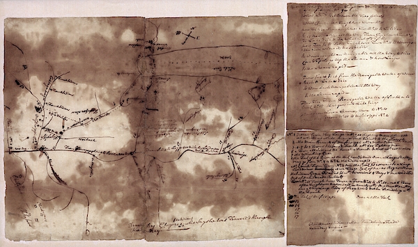
French and Indian War map. 18th-century map of the lands along the Mississippi River, drawn in around 1755 by a Native American named Chegeree. The... more
Ships Within
2 - 3 business days
French and Indian War map. 18th-century map of the lands along the Mississippi River, drawn in around 1755 by a Native American named Chegeree. The map is oriented with north toward upper right. It shows the area from Lake Erie to the mouth of the Ohio River. The sheets at right consist of questions and information relating to the map. It is thought the map was made for a British official during the French and Indian War of 1754 to 1763. The map shows French military strength in the Ohio and Mississippi River valleys. The French and British were fighting for control of the North American interior. Identified locations include Fort Duquesne ('French Fort').
Science Photo Library (SPL) is the leading source of science images and footage. Sourced from scientific and medical experts, acclaimed photographers and renowned institutions, our content is unrivaled worldwide. Outstanding quality, accuracy and commitment to excellence are deeply embedded in our DNA. Science Photo Library inspires creative professionals and delivers engaging content of the highest quality for a wide range of clients in a variety of sectors. Visit sciencephoto.com for more information and stay connected on Twitter, LinkedIn, Instagram and Vimeo.
$30.00


Copyright © 2024 sciencephotogallery.com - All Rights Reserved - Website Powered by Fine Art America / Pixels - Original Source - Tapestries


There are no comments for French And Indian War Map. Click here to post the first comment.