
Boundary: Bleed area may not be visible.

Inside Message (Optional)
Inside View

by Library Of Congress, Geography And Map Division
$30.00
Quantity
The more you buy... the more you save.
Orientation
Image Size
Product Details
Our greeting cards are 5" x 7" in size and are produced on digital offset printers using 100 lb. paper stock. Each card is coated with a UV protectant on the outside surface which produces a semi-gloss finish. The inside of each card has a matte white finish and can be customized with your own message up to 500 characters in length. Each card comes with a white envelope for mailing or gift giving.
Design Details
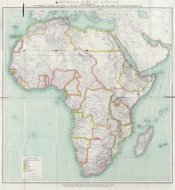
Map of Africa. Political map showing African regional boundaries in 1909. The Berlin Conference of 1884-85 had formalised the division of Africa... more
Ships Within
2 - 3 business days
Map of Africa. Political map showing African regional boundaries in 1909. The Berlin Conference of 1884-85 had formalised the division of Africa among the European powers. The borders are colour-coded (key at bottom left): British (pink, mainly Sudan and southern Africa), French (red, mainly French West Africa), Italian (blue), German (orange), Portuguese (green), Spanish (dark brown), and Belgian (light brown). Independent states are yellow: Liberia, Morocco, Egypt and Ethiopia. This map is from the 1909 edition of 'The Map of Africa by Treaty' (first edition 1895 by Edward Hertslet) by Richard William Brant and Harry Leslie Sherwood.
Science Photo Library (SPL) is the leading source of science images and footage. Sourced from scientific and medical experts, acclaimed photographers and renowned institutions, our content is unrivaled worldwide. Outstanding quality, accuracy and commitment to excellence are deeply embedded in our DNA. Science Photo Library inspires creative professionals and delivers engaging content of the highest quality for a wide range of clients in a variety of sectors. Visit sciencephoto.com for more information and stay connected on Twitter, LinkedIn, Instagram and Vimeo.
$30.00


Copyright © 2024 sciencephotogallery.com - All Rights Reserved - Website Powered by Fine Art America / Pixels - Original Source - Tapestries


There are no comments for Map Of Africa #1. Click here to post the first comment.