
Boundary: Bleed area may not be visible.

Inside Message (Optional)
Inside View

by Library Of Congress, Geography And Map Division
$30.00
Quantity
The more you buy... the more you save.
Orientation
Image Size
Product Details
Our greeting cards are 5" x 7" in size and are produced on digital offset printers using 100 lb. paper stock. Each card is coated with a UV protectant on the outside surface which produces a semi-gloss finish. The inside of each card has a matte white finish and can be customized with your own message up to 500 characters in length. Each card comes with a white envelope for mailing or gift giving.
Design Details
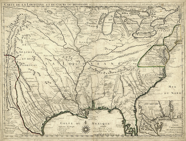
Map of French Louisiana. 18th-century map of French Louisiana (in New France) in North America, centred on the Mississippi and its tributaries. The... more
Ships Within
2 - 3 business days
Map of French Louisiana. 18th-century map of French Louisiana (in New France) in North America, centred on the Mississippi and its tributaries. The Great Lakes and British colonies, Florida, and Spanish New Mexico, are all shown. Numerous Native American tribes are named and ancient pre-Columbian sites such as Cahokia ('Ancien Village de Illinois'). The inset shows the Mississippi Delta on the Gulf of Mexico, and the colony of Fort Louis (Mobile-Tensaw delta). Explorers and their routes given on the map include: Cavelier (La Salle), St Denis and Hernando de Soto. Published in Paris in 1718 by French cartographer Guillaume de L'Isle (1675-1726).
Science Photo Library (SPL) is the leading source of science images and footage. Sourced from scientific and medical experts, acclaimed photographers and renowned institutions, our content is unrivaled worldwide. Outstanding quality, accuracy and commitment to excellence are deeply embedded in our DNA. Science Photo Library inspires creative professionals and delivers engaging content of the highest quality for a wide range of clients in a variety of sectors. Visit sciencephoto.com for more information and stay connected on Twitter, LinkedIn, Instagram and Vimeo.
$30.00


Copyright © 2024 sciencephotogallery.com - All Rights Reserved - Website Powered by Fine Art America / Pixels - Original Source - Tapestries


There are no comments for Map Of French Louisiana. Click here to post the first comment.