
Boundary: Bleed area may not be visible.

Inside Message (Optional)
Inside View

by Mda Information Systems/science Photo Library
$5.00
Quantity
The more you buy... the more you save.
Orientation
Image Size
Product Details
Our greeting cards are 5" x 7" in size and are produced on digital offset printers using 100 lb. paper stock. Each card is coated with a UV protectant on the outside surface which produces a semi-gloss finish. The inside of each card has a matte white finish and can be customized with your own message up to 500 characters in length. Each card comes with a white envelope for mailing or gift giving.
Design Details
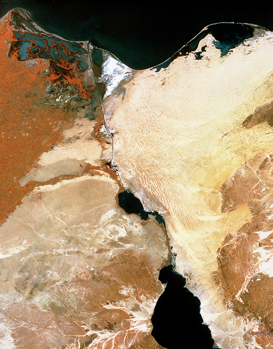
Suez Canal. Infrared satellite image of the Suez canal (at centre), Egypt, with parts of the Nile Delta (at left) and Sinai peninsula (at right).... more
Ships Within
2 - 3 business days
Suez Canal. Infrared satellite image of the Suez canal (at centre), Egypt, with parts of the Nile Delta (at left) and Sinai peninsula (at right). North is at top. In the infrared range water appears black, barren areas are yellow & brown, buildings are grey and green vegetation is red. The Suez canal links the Red (at bottom centre) and Mediterranean (at top) seas. At the north end of the canal is Port Said and at the south end is Suez. The canal passes through the salty Great Bitter Lake (at lower centre). The canal provides the fastest route between Europe and Asia. Image taken by the American Landsat satellite.
Science Photo Library (SPL) is the leading source of science images and footage. Sourced from scientific and medical experts, acclaimed photographers and renowned institutions, our content is unrivaled worldwide. Outstanding quality, accuracy and commitment to excellence are deeply embedded in our DNA. Science Photo Library inspires creative professionals and delivers engaging content of the highest quality for a wide range of clients in a variety of sectors. Visit sciencephoto.com for more information and stay connected on Twitter, LinkedIn, Instagram and Vimeo.
$5.00


Copyright © 2024 sciencephotogallery.com - All Rights Reserved - Website Powered by Fine Art America / Pixels - Original Source - Tapestries


There are no comments for Infrared Satellite Image Of Suez Canal & Nile Dlta. Click here to post the first comment.