
Boundary: Bleed area may not be visible.

Inside Message (Optional)
Inside View

by Patrick Landmann/science Photo Library
$5.00
Quantity
The more you buy... the more you save.
Orientation
Image Size
Product Details
Our greeting cards are 5" x 7" in size and are produced on digital offset printers using 100 lb. paper stock. Each card is coated with a UV protectant on the outside surface which produces a semi-gloss finish. The inside of each card has a matte white finish and can be customized with your own message up to 500 characters in length. Each card comes with a white envelope for mailing or gift giving.
Design Details
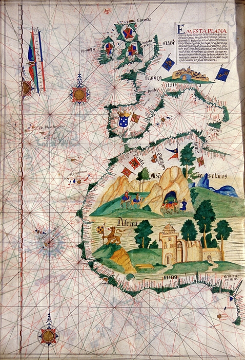
Portuguese sea chart. 16th century nautical chart of the coastlines of Western Europe (top) and West Africa (bottom). North is at top. The chart... more
Ships Within
2 - 3 business days
Portuguese sea chart. 16th century nautical chart of the coastlines of Western Europe (top) and West Africa (bottom). North is at top. The chart shows the names of locations along the coastlines, and gives lines used for navigation at sea. Artworks of camels and a castle fill the African interior. Nautical charts such as these were used during the Age of Discovery, that included the 1497-9 voyage of the Portuguese explorer Vasco da Gama, which opened the maritime trading route from Europe round Africa to India. This map is from a 1563 atlas by the Portuguese cartographer Lazaro Luis, at the Sciences Academy of Lisbon.
Science Photo Library (SPL) is the leading source of science images and footage. Sourced from scientific and medical experts, acclaimed photographers and renowned institutions, our content is unrivaled worldwide. Outstanding quality, accuracy and commitment to excellence are deeply embedded in our DNA. Science Photo Library inspires creative professionals and delivers engaging content of the highest quality for a wide range of clients in a variety of sectors. Visit sciencephoto.com for more information and stay connected on Twitter, LinkedIn, Instagram and Vimeo.
$5.00


Copyright © 2024 sciencephotogallery.com - All Rights Reserved - Website Powered by Fine Art America / Pixels - Original Source - Tapestries


There are no comments for Portuguese Sea Chart #1. Click here to post the first comment.